
@savageupdatesThe Byzantine Empire existed around 1265 AD
원본 게시물 보기@savageupdatesThe Byzantine Empire existed around 1265 AD
원본 게시물 보기@savageupdates님의 사진· Oct 6, 2026· Info/Editorials
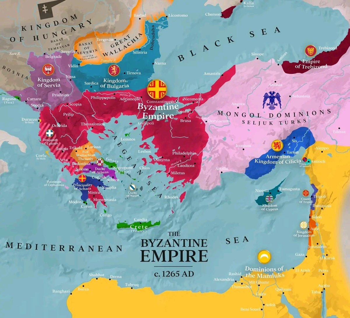
This is a historical map depicting the Byzantine Empire around 1265 AD. The focus is on the territorial extent of the Byzantine Empire and its surrounding political entities. The map uses distinct colors to differentiate between the Byzantine Empire, the Kingdom of Hungary, the Kingdom of Serbia, the Kingdom of Bulgaria, the Mongol Dominions of Seljuk Turks, the Armenian Kingdom of Cilicia, the Dominions of the Mamluks, and other smaller principalities and duchies. The overall style is informative and educational, typical of historical cartography. A notable detail is the inclusion of various city names and geographical features like seas and rivers, along with emblems for some of the larger political powers. The on-screen text clearly labels "THE BYZANTINE EMPIRE c. 1265 AD".
@savageupdatesThe Byzantine Empire existed around 1265 AD
원본 게시물 보기@savageupdates님의 사진· Oct 6, 2026· Info/Editorials
This is a historical map depicting the Byzantine Empire around 1265 AD. The focus is on the territorial extent of the Byzantine Empire and its surrounding political entities. The map uses distinct colors to differentiate between the Byzantine Empire, the Kingdom of Hungary, the Kingdom of Serbia, the Kingdom of Bulgaria, the Mongol Dominions of Seljuk Turks, the Armenian Kingdom of Cilicia, the Dominions of the Mamluks, and other smaller principalities and duchies. The overall style is informative and educational, typical of historical cartography. A notable detail is the inclusion of various city names and geographical features like seas and rivers, along with emblems for some of the larger political powers. The on-screen text clearly labels "THE BYZANTINE EMPIRE c. 1265 AD".
아직 댓글이 없습니다. 첫 댓글을 남겨보세요!


아직 댓글이 없습니다. 첫 댓글을 남겨보세요!