iFANN
    iFANN 검색...
    로그인
    홈
    뉴스
    동영상
    사진
    GIF
    탐색
    투표
    어워드
    iFAMOUS
    위키
    애니
    룸
    알림
    메시지
    북마크
    프로필
    위키어워드iFAMOUS랭킹산업크리에이터 리워드사용자 리워드약관개인정보커뮤니티 가이드라인게시 중단 / DMCA도움말개발자

    © 2026 iFANN

    홈
    검색
    메시지
    알림
    프로필
    사진
    Savage Updates
    Savage Updates@savageupdates2mo
    💭Info/Editorials
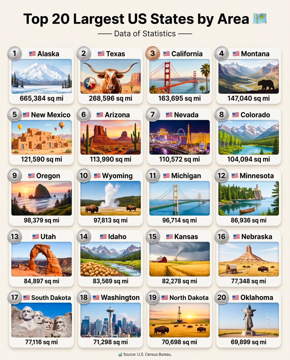
    Top 20 Largest US States by Area

    @savageupdatesTop 20 Largest US States by Area 🗺️ 1. 🇺🇸 Alaska — 665,384 sq mi 2. 🇺🇸 Texas — 268,596 sq mi 3. 🇺🇸 California — 163,695 sq mi 4. 🇺🇸 Montana — 147,040 sq mi 5. 🇺🇸 New Mexico — 121,590 sq mi 6. 🇺🇸 Arizona — 113,990 sq mi 7. 🇺🇸 Nevada — 110,572 sq mi 8. 🇺🇸 Colorado — 104,094 sq mi 9. 🇺🇸 Oregon — 98,379 sq mi 10. 🇺🇸 Wyoming — 97,813 sq mi 11. 🇺🇸 Michigan — 96,714 sq mi 12. 🇺🇸 Minnesota — 86,936 sq mi 13. 🇺🇸 Utah — 84,897 sq mi 14. 🇺🇸 Idaho — 83,569 sq mi 15. 🇺🇸 Kansas — 82,278 sq mi 16. 🇺🇸 Nebraska — 77,348 sq mi 17. 🇺🇸 South Dakota — 77,116 sq mi 18. 🇺🇸 Washington — 71,298 sq mi 19. 🇺🇸 North Dakota — 70,698 sq mi 20. 🇺🇸 Oklahoma — 69,899 sq mi 🧾 Note: This ranking uses total area (land + water), not land area alone. 📊 Source: U.S. Census Bureau.

    원본 게시물 보기

    Top 20 Largest US States by Area

    @savageupdates님의 사진· Sep 14, 2026· Info/Editorials

    이 사진에 대해

    The image is a graphic displaying the top 20 largest US states by area. Each state is presented in a numbered box with its name, a representative illustration, and its area in square miles. The overall style is informative and visually appealing, with vibrant illustrations. A notable detail is the inclusion of the U.S. Census Bureau as the source at the bottom. ON-SCREEN TEXT: Top 20 Largest US States by Area. Data of Statistics. Source: U.S. Census Bureau.

    Info/Editorials 사진 전체 보기

    ?

    아직 댓글이 없습니다. 첫 댓글을 남겨보세요!

    Info/Editorials 사진 더 보기

    Info/Editorials 사진 전체 보기
    World map country sizesWorld map country sizesNumbeo affordable cities 20262Numbeo affordable cities 2026main European regions mapmain European regions mapAfrica forest cover by countryAfrica forest cover by countryRome Italy most walkable city2Rome Italy most walkable cityAsian Country Urban Population MapAsian Country Urban Population MapGlobal Nuclear Power Capacity 20252Global Nuclear Power Capacity 2025US State population under 25 shareUS State population under 25 shareLionel Messi jersey stars2Lionel Messi jersey starsPoland 17th century vs today mapPoland 17th century vs today mapImmigrant population map by stateImmigrant population map by stateTallest men by U.S. state mapTallest men by U.S. state mapUS climate zones by locationUS climate zones by location
    사진
    Savage Updates
    Savage Updates@savageupdates2mo
    💭Info/Editorials
    Top 20 Largest US States by Area

    @savageupdatesTop 20 Largest US States by Area 🗺️ 1. 🇺🇸 Alaska — 665,384 sq mi 2. 🇺🇸 Texas — 268,596 sq mi 3. 🇺🇸 California — 163,695 sq mi 4. 🇺🇸 Montana — 147,040 sq mi 5. 🇺🇸 New Mexico — 121,590 sq mi 6. 🇺🇸 Arizona — 113,990 sq mi 7. 🇺🇸 Nevada — 110,572 sq mi 8. 🇺🇸 Colorado — 104,094 sq mi 9. 🇺🇸 Oregon — 98,379 sq mi 10. 🇺🇸 Wyoming — 97,813 sq mi 11. 🇺🇸 Michigan — 96,714 sq mi 12. 🇺🇸 Minnesota — 86,936 sq mi 13. 🇺🇸 Utah — 84,897 sq mi 14. 🇺🇸 Idaho — 83,569 sq mi 15. 🇺🇸 Kansas — 82,278 sq mi 16. 🇺🇸 Nebraska — 77,348 sq mi 17. 🇺🇸 South Dakota — 77,116 sq mi 18. 🇺🇸 Washington — 71,298 sq mi 19. 🇺🇸 North Dakota — 70,698 sq mi 20. 🇺🇸 Oklahoma — 69,899 sq mi 🧾 Note: This ranking uses total area (land + water), not land area alone. 📊 Source: U.S. Census Bureau.

    원본 게시물 보기

    Top 20 Largest US States by Area

    @savageupdates님의 사진· Sep 14, 2026· Info/Editorials

    이 사진에 대해

    The image is a graphic displaying the top 20 largest US states by area. Each state is presented in a numbered box with its name, a representative illustration, and its area in square miles. The overall style is informative and visually appealing, with vibrant illustrations. A notable detail is the inclusion of the U.S. Census Bureau as the source at the bottom. ON-SCREEN TEXT: Top 20 Largest US States by Area. Data of Statistics. Source: U.S. Census Bureau.

    Info/Editorials 사진 전체 보기

    ?

    아직 댓글이 없습니다. 첫 댓글을 남겨보세요!

    Info/Editorials 사진 더 보기

    Info/Editorials 사진 전체 보기
    World map country sizesWorld map country sizesNumbeo affordable cities 20262Numbeo affordable cities 2026main European regions mapmain European regions mapAfrica forest cover by countryAfrica forest cover by countryRome Italy most walkable city2Rome Italy most walkable cityAsian Country Urban Population MapAsian Country Urban Population MapGlobal Nuclear Power Capacity 20252Global Nuclear Power Capacity 2025US State population under 25 shareUS State population under 25 shareLionel Messi jersey stars2Lionel Messi jersey starsPoland 17th century vs today mapPoland 17th century vs today mapImmigrant population map by stateImmigrant population map by stateTallest men by U.S. state mapTallest men by U.S. state mapUS climate zones by locationUS climate zones by location